(News from the Research Center for Spatio-Temporal Intelligent Systems Engineering, Hong Kong Academy of Technology)
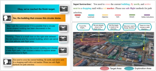
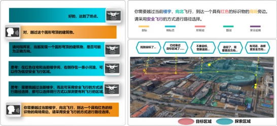
On December 23, 2025, core team members including Chao E and Bin Zhang from the Research Center for Spatio-Temporal Intelligent Systems Engineering of the Hong Kong Academy of Technology published their research paper “Exploratory UAV Autonomous Visual Navigation with Spatio-Temporal Cognition.” The paper focuses on the challenges of satellite positioning signal failure in extreme environments—where UAVs are prone to losing their way and crashing—and the tendency of existing vision-language-navigation technologies to fail when encountering undefined target points. It proposes the UAV exploratory navigation system, UAV E-Nav.
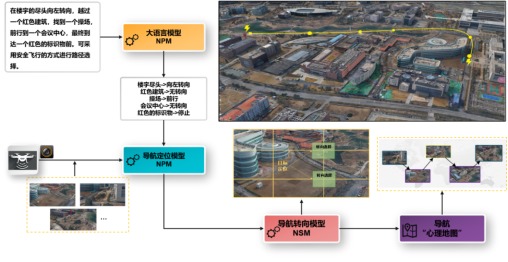
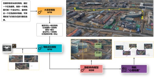
The UAV E-Nav system builds large pre-trained UAV navigation language, vision, and action models, incorporating the spatio-temporal cognition and safe flight experience of senior navigators into the model tuning process to achieve cross-modal fusion and adaptation of language, vision, and knowledge. The system consists of a Large Language Model (LLM), a Navigation Positioning Model (NPM), and a Navigation Steering Model (NSM). It extracts landmark names and action adverbs from natural language, maps them to the real world through a vision-language model, determines the next flight direction via the navigation steering model, and synchronously stores the information in a “cognitive map.” Requiring no fine-tuning or language annotation data, the system exhibits strong generalization capability in real-world scenarios. Based on this system, instance-based verification of UAV navigation in real scenes was completed; with satellite positioning disabled, natural language instructions successfully enabled long-range exploratory navigation in complex outdoor environments. This research provides new ideas and paradigms for UAV exploratory navigation and enhances the engineering practicality of human-UAV interaction.
Exploratory UAV Autonomous Visual Navigation with Spatio-Temporal Cognition
On December 23, 2025, core team members including Chao E and Bin Zhang from the Research Center for Spatio-Temporal Intelligent Systems Engineering of the Hong Kong Academy of Technology published the research paper “Exploratory UAV Autonomous Visual Navigation with Spatio-Temporal Cognition”. Focusing on the challenges of satellite positioning signal failure in extreme environments (which causes UAVs to easily get lost and crash) and the common navigation failure of existing vision-language-navigation technologies when encountering undefined target points, the paper proposes the UAV exploratory navigation system UAV E-Nav.
The UAV exploratory navigation system UAV E-Nav constructs a large pre-trained UAV navigation language-vision-action model, integrating the spatio-temporal cognition and safe flight experience of senior navigators into the model tuning process to achieve cross-modal fusion and adaptation of language, vision, and knowledge. The system comprises three core components: the Large Language Model (LLM), the Navigation Positioning Model (NPM), and the Navigation Steering Model (NSM). It extracts landmark names and action adverbs from natural language instructions, completes real-world mapping via a vision-language model, determines the next flight direction through the navigation steering model, and synchronously stores information in a “cognitive map”. Requiring no additional fine-tuning or language annotation data, the system demonstrates strong generalization capability in real-world scenarios.
Instance verification of UAV navigation based on this system has been completed. With satellite positioning fully disabled, the system successfully realized long-distance exploratory navigation in complex outdoor environments using only natural language instructions. This research provides new ideas and paradigms for UAV exploratory navigation, and improves the engineering practicality of human-UAV interaction.